Select to expand quoteBlueMoon said..
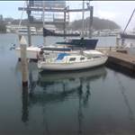
For the last few years, I have run iSailor on an iPad2, and have found it very good, detailed, easy to look at and do stuff on it. Have found a few errors though, I was once sailing along the footpath at Tuncurry, and there was an uncharted rock off Bustard Head light, right on my track that would ave been disastrous, if I wasn't keeping a lookout.
i made a one off payment of about $55 for the East coast, I think it's now an annual subscription, since Transas sold it to wartsila.
as a back up I also have Navionics on the phone, which I use if I'm not sure of something. Someone showed me navionics with the "community edits" function, that shows detailed depth contours, I was quite impressed with that.
Bustard head. That would either be inner rock, middle rock or outer rock. I will have a look on mine.
Select to expand quoteKarsten said..
A few votes here for OpenCPN, and some for Navionics.
I understand that you get chart data included with Navionics and that is really what you pay for periodically.
But those using OpenCPN (and there are a few here), where do you get reasonably up-to-date Aus East coast chart data, and what does it cost once-off or periodically ?
I have been using OpenCPN with CM 93 charts for about 6 years, first on a netbook and now an android tablet. Open CPN readily displays AIS and NMEA GPS data via wifi and I'm very happy with it. pm me for advice on sourcing the charts.
Cheers, Graeme
Select to expand quoteShanty said..BlueMoon said..
For the last few years, I have run iSailor on an iPad2, and have found it very good, detailed, easy to look at and do stuff on it. Have found a few errors though, I was once sailing along the footpath at Tuncurry, and there was an uncharted rock off Bustard Head light, right on my track that would ave been disastrous, if I wasn't keeping a lookout.
i made a one off payment of about $55 for the East coast, I think it's now an annual subscription, since Transas sold it to wartsila.
as a back up I also have Navionics on the phone, which I use if I'm not sure of something. Someone showed me navionics with the "community edits" function, that shows detailed depth contours, I was quite impressed with that.
Bustard head. That would either be inner rock, middle rock or outer rock. I will have a look on mine.
It's the drying rock 3/4 of the way from Inner Rock to Middle Rocks, I've just had another look at it on iSailor and to be fair, it was my user error, I missed the underlined depth that was in red on the iPad screen in daylight, I would have liked a rock symbol, or different colour background denoting something, just reminded me that you need to be careful.
im interested what yours shows Mick,
cheers
Select to expand quoteBlueMoon said..Shanty said..BlueMoon said..
For the last few years, I have run iSailor on an iPad2, and have found it very good, detailed, easy to look at and do stuff on it. Have found a few errors though, I was once sailing along the footpath at Tuncurry, and there was an uncharted rock off Bustard Head light, right on my track that would ave been disastrous, if I wasn't keeping a lookout.
i made a one off payment of about $55 for the East coast, I think it's now an annual subscription, since Transas sold it to wartsila.
as a back up I also have Navionics on the phone, which I use if I'm not sure of something. Someone showed me navionics with the "community edits" function, that shows detailed depth contours, I was quite impressed with that.
Bustard head. That would either be inner rock, middle rock or outer rock. I will have a look on mine.
It's the drying rock 3/4 of the way from Inner Rock to Middle Rocks, I've just had another look at it on iSailor and to be fair, it was my user error, I missed the underlined depth that was in red on the iPad screen in daylight, I would have liked a rock symbol, or different colour background denoting something, just reminded me that you need to be careful.
im interested what yours shows Mick,
cheers
For the Ipad, I'm a bit like BlueMoon, ISailor and I've only recently downloaded Navionics for a second dataset, with Cmaps in Adrena on the PC downstairs as the third via: Splashtop.
Select to expand quotewongaga said..
I have been using OpenCPN with CM 93 charts for about 6 years, first on a netbook and now an android tablet.
Hi Graeme,
I have the CM 93 charts for the world on CDR.
I am thinking that I should be able to copy them to lap top and then copy them a Micro SD with a reader and then put the SD card into the tablet then point Open CPN at the folders.
Would that work??
Select to expand quotecisco said..
I have the CM 93 charts for the world on CDR.
I am thinking that I should be able to copy them to lap top and then copy them a Micro SD with a reader and then put the SD card into the tablet then point Open CPN at the folders.
Would that work??
I don't see why not - I've copied this folder everywhere & as long as you point OpenCPN to the correct directory it should work.
I bought the Au maps a while ago & there really isn't that much of a difference I have spotted as yet. Gonna lose them though with next upgrade. :(
I wander why no one mention Garmin Blue Charts. Run app on iPad 2, as reference only. A few years ago, it was really
cheap, no subscription. Well, you get what you pay for. This is one of many discrepancy , is it normal or its just Blue Charts? I know my build in GPS is precise, I also run TomTom, work well.

Select to expand quoteBlueMoon said..Shanty said..BlueMoon said..
For the last few years, I have run iSailor on an iPad2, and have found it very good, detailed, easy to look at and do stuff on it. Have found a few errors though, I was once sailing along the footpath at Tuncurry, and there was an uncharted rock off Bustard Head light, right on my track that would ave been disastrous, if I wasn't keeping a lookout.
i made a one off payment of about $55 for the East coast, I think it's now an annual subscription, since Transas sold it to wartsila.
as a back up I also have Navionics on the phone, which I use if I'm not sure of something. Someone showed me navionics with the "community edits" function, that shows detailed depth contours, I was quite impressed with that.
Bustard head. That would either be inner rock, middle rock or outer rock. I will have a look on mine.
It's the drying rock 3/4 of the way from Inner Rock to Middle Rocks, I've just had another look at it on iSailor and to be fair, it was my user error, I missed the underlined depth that was in red on the iPad screen in daylight, I would have liked a rock symbol, or different colour background denoting something, just reminded me that you need to be careful.
im interested what yours shows Mick,
cheers

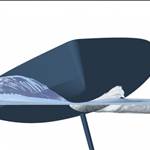
For some reason the photos sideways. The only way to even tell that comes out of the water is the underline of the blue number 2.1. It would indeed be nice to see a rock symbol there.
Regards,
Mick
The Navionics WebApp is a handy tool as well - you obviously need internet connection but handy when planning:
webapp.navionics.com/#boating@12&key=n%7BnqCwgj%7D%5B
This shows a rock & somewhere I would probably go around at night!!
You can use the Navionics overlay or the SonarChart overlay (icon in lower LH corner) which is sourced from input from you & me.

I've been using Cmap-Embark on my phone recently. Old reliable Navionics became unreliable ????. Embark is free. I don't actually use it offshore for navigation, but great for research, planning voyages & looking at charts ! ??
I've been using Cmap-Embark on my phone recently. Old reliable Navionics became unreliable ????. Embark is free. I don't actually use it offshore for navigation, but great for research, planning voyages & looking at charts ! ??
Select to expand quotecisco said..wongaga said..
I have been using OpenCPN with CM 93 charts for about 6 years, first on a netbook and now an android tablet.
Hi Graeme,
I have the CM 93 charts for the world on CDR.
I am thinking that I should be able to copy them to lap top and then copy them a Micro SD with a reader and then put the SD card into the tablet then point Open CPN at the folders.
Would that work??
Yep. That's pretty much how I loaded them onto my Galaxy tablet, except I did it with a USB drive.