The technology is out there. I know you'll back me up on this one Macro.

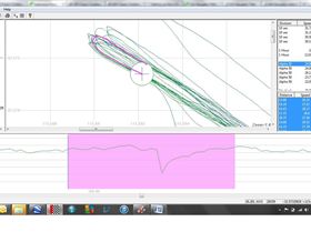
You know what it's like, you think you've done pretty well at the local beach, posted up a 28 knot 2 second on GPSTC and then find your mate at the estuary just around the corner has just done 38 knots. Embarrassing. ( You'll note KA72 doesn't let you decide against posting such ordinary numbers until it's too late! )
Now it's already probably a sensible thing to pack a phone in a water proof container when you leave shore. Why not put it to work? Whether a smart phone's accelerometer can work out the wave directional spectrum at full speed or whether a few non-planing runs in a few directions will be needed would take a bit of experimentation.
http://www.tos.org/oceanography/archive/10-2_wyatt.pdfIt would have to be mounted in a standard location, at the foot of the mast maybe.
If data from runs at full speed is meaningful the Smart phone's gps will allow merging with the primary GPS file.
www.onlinegrammar.com.au/top-10-grammar-myths-data-is-plural-so-must-take-a-plural-verb/Simplifying the wave directional spectrum into a couple of realistic categories will take a bit of experimentation and programming.
Smart phone accelerometers may not be absolutely accurate devices, but calibration should be possible. Mount one side by side with a verified one, spin then around a bit, and let them sort it out.
Of course if you always speed sail in smooth water you wouldn't have to pack a smart phone. You'd continue to post in the default "smooth" category.