For sure. I agree. Do you think these 70 hour weeks have been pure fun? (ok, they were) ... but .. fact is, it was broken.
The technology we used got retired, got old, and isn't supported any more. Just like your old Holden. Or Nokia Phone. Stuff gets old, and we have no choice but to upgrade. And, we wanted to add new stuff, and the "More Weather" drop down wasn't cutting it.
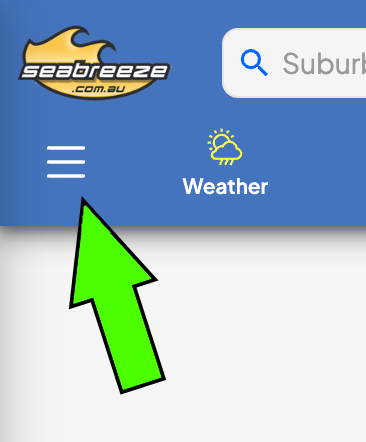
We couldn't add what we needed, so we had to redesign it a little bit, and all that's happened is the "More Weather" has moved to a hamburger menu at the top left (on desktop). See above. Tap on him, and a whole new world (and all your previous world) exists under here.
It has it all. Just the names may have been changed to protect the innocent. Why have "Perth" in front of every label. Perth Sun Time, Perth Rain Radar, Perth Synoptics .. they are now just labelled "Sun", "Radar" and "Synoptics". Think of how you can spend all that extra time not having to read all those lengthly labels! #winning
Hope that helps. If you still can't find what you're looking for, let me know.
And please, be patient. The site is BRAND NEW, and it's having a few teething issues, despite our famed list of testers testing everything.
Enjoy!
 icon located at the top left of each graph.
When you select the icon, it turns sold
icon located at the top left of each graph.
When you select the icon, it turns sold
 to shows that you've select the graph in your favourites.
Continue picking the graphs you want. If necessary, visit any other graph pages to add other graphs of interest.
When finished, view your favourites, page by selecting the
Graphs / My Graphs
menu.
Once there, you should find the weather graphs you selected.
You can easily remove graphs no longer required by deselecting the favourites icon at the top left of each graphic.
You can also shuffle the order, by using the Move Up/Down icons ..
to shows that you've select the graph in your favourites.
Continue picking the graphs you want. If necessary, visit any other graph pages to add other graphs of interest.
When finished, view your favourites, page by selecting the
Graphs / My Graphs
menu.
Once there, you should find the weather graphs you selected.
You can easily remove graphs no longer required by deselecting the favourites icon at the top left of each graphic.
You can also shuffle the order, by using the Move Up/Down icons ..
 ,
,
 .
You don't even need to register or login to use the favourites.
Trouble shooting:
If you find it's not remembering your settings, check the cookie settings in your browser! No cookies = no favourites.. sorry.
.
You don't even need to register or login to use the favourites.
Trouble shooting:
If you find it's not remembering your settings, check the cookie settings in your browser! No cookies = no favourites.. sorry.
|
Wind Glorious Wind...
If you're into a sport that is affected by the wind, it pays to understand how wind works. Wind... Wind is the movement of air molecules from one location to another. The perfect demonstration of wind is with a fully inflated car tyre. If you open the valve on the car tyre, air rushes out. Why? Because there is more air pressure in the tyre than there is in the atmosphere, and the atmosphere is always seeking to equalise pressure. Higher pressure pockets of air (i.e. inside the car tyre) move to equalise lower pressure areas. So what causes these low pressure areas? Well, in the case of a seabreeze, it's caused by heat... Seabreezes... Cold sinks, heat rises. It's the concept that makes hot air balloons work, and why your vegies are at the bottom of the fridge. During a summer day, the land is heated by the sun, and this heat is absorbed by the surrounding air. Once this air meets a particular temperature, it begins to rise quite rapidly. As a result, a low pressure area is created at ground level. The sea doesn't heat up as quickly as the land, so the air temperature over the water is much less. As a result, this air is free to move sideways to occupy our new low pressure area. The result is a light to gale force wind which rushes in from the sea to fill the lower pressure area left by the hot air rising from the land. Seabreezes usually happen in spring and summer, when the difference in temperature between land and sea is greatest. Seabreezes are the most amazing phenonenom. For many years I never really paid much attention to the wind. One day, we arrived (late) at the local river to do some water skiing. It was around 1pm, the water was glassy - perfect conditions. Then, my mate Mick says "Here comes the seabreeze...". Looking across the river we could see an approaching line of rough water. And then it hit us full on - the full glory of a 25 knot seabreeze. What's even more amazing is that the wind can be travelling faster than the front of the seabreeze. It can be progressing inland at 25 km/h, but the actual wind can be blowing at 35 km/h! Sometimes the seabreeze can reach 100+ kilometers inland, and other days it teases you by staying just offshore, coming in, and then going out again. So to get a seabreeze, it needs to be hot inland. But too hot and you won't get one at all. To explain why this is the case, we need to understand high's and low's and the squiqqly charts they show on the telly called 'Synoptic Charts'. Synoptic Charts... You need to understand these if you want to have your own guess at what the wind may do. It also assists to understand what the weather man is talking about. Sometimes our local TV weather reports simply say '.. and an afternoon seabreeze'. About as useful as an ashtray on a motorbike. So check this out:
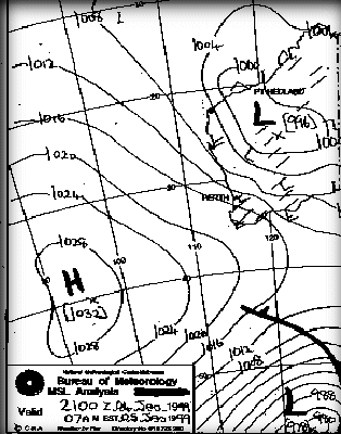
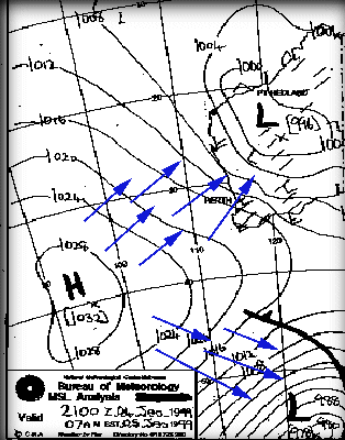
From the title, it says MSL Analysis. This means it is a Mean (average) Sea Level Analysis. A slice of the atmosphere at sea level. The way the atmosphere changes at different levels is also extremely interesting, but beyond what we talking about here. The numbers indicate the air pressure, called the Barometric pressure. Barometric pressure is measured in hectopascals. Bigger numbers represent greater air pressure. The chart is generated by acquiring a huge number of readings from ships, sea based automatic weather buoys and land based weather stations. These data points are then processed using complex mathamatics to 'best guess' or 'interpolate' values for areas where no reading was available. The meteorologist then sharpens his best HB pencil and draws lines connecting areas of equal pressure (called isobars, or contours), draws a H in the middle of any Highs, and an L in the middle of any Lows. They also draw another chart called a prognosis which is what they estimate to be where the weather will go. It's always valuable to compare the analysis with the prognosis to get an idea of where, and at what speed the weather is travelling. So high pressure areas rush to fill low pressure areas huh? If that was the case, then you would expect the wind to travel like this:
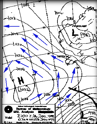
Bzzzzzzzt. Wrong! These are complex systems, and there's other forces at work here, plus lets not forget that the world is 3D and this is only a horizontal slice. The world is spinning, which creates an extra sideways force. To simplify, visualise the surface of a spinning tennis ball. There is a "wind" blowing across the surface of the tennis ball due to its rotation. As a result, wind actually travels pretty much in the direction of the isobar lines. And in the southern hemisphere they travel anti-clockwise around high's and clockwise around lows. And the whole weather pattern moves (generally) in a west to east (left to right) direction. So the wind actually blows around the high cell like this:
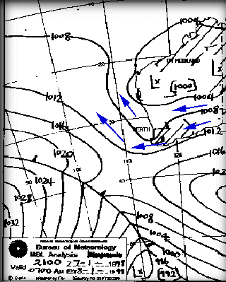
This all adds up to help determine the kind of local wind effects such as seabreezes along the coast in the afternoon. This synoptic chart is a joy to a wind fanatic living on the coast of Western Australia because this pattern means wind - and lots of it - these cool winds also keep the maximum temperature down. In fact, the forecast for this pattern was: TODAY'S MAX: 23 C (74 F) Strong Wind Warning current. S/SE winds 20/30kn in the morning, tending S/SW and strengthening to 25/32kn in the afternoon.The S/SE winds in the morning reflect the anti-clockwise direction of wind around the high, untill the afternoon when the thermal induced seabreeze kicks in and changes to an onshore S/SW. But that low cell sitting up in the north is what can ruin it all. These low pressure systems descend in a southerly fashion and bring with them hot and humid conditions. They are called troughs and generally spoil any chance of a seabreeze, as indicated with this chart and forecast:
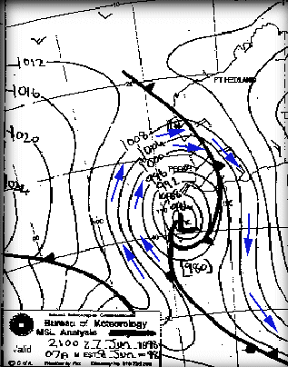
FORECAST: TODAY'S MAX: 35 C (95 F) E/NE winds 15/20kn, easing to 10/15kn by late morning. Winds shifting NW/SW 10/15kn during the afternoon.The capital city of Perth is going to be blasted with E/NE winds in the morning, brought in nice and fresh from the deserts, and these winds are toasty - a maximum of 35 degrees C, and only a mild, if any, seabreeze. But wait - that's a cold front approaching from the south west, and there's a good chance that this will push the trough inland and bring back the seabreezes. Generally speaking the thing to look for when looking for strong seabreezes is a new high cell aproaching (following a previous high cell), or a tough moving inland and being replaced by a new high (extra windy!). Cold Fronts... Well, unlike seabreezes, cold fronts are active mainly during winter and come at any time of day or night. Cold fronts do pass through during the other months, but their effect is usually not noticed by most. Like seabreezes, they come in all sorts of flavours from simply making the sky cloudy to full on roof removing gale force winds. Cold fronts, as the name suggests, is a line of cold air travelling along, generally west to east. As this cold air meets warmer air, the warm air rises, and you guessed it, causes the cold air to rush in and fill the space. Thus, the actual 'front' of the front, called the 'squall line' is generally where most of the wind is. Cold fronts are great when they come through, producing great local names, such as the 'Norwester'. Because the winds travel clockwise around a low pressure system, the first taste you get is Northerly, but more often than not North Westerly. As the cold front passes through these winds rotate around the compass, going from NW to W to SW, and maybe S. The S part can get quite chilly because it's dredging all the cool air from the antarctic region. Not cold by UK standards, but enough to make your face numb. North Westerlies on the otherhand can be quite warm, relative to the usual winter temperatures. The time it takes for the NW to SW transition depends on the speed at which the front is travelling. Usually around a day, sometimes two. Time to introduce another term - the pressure gradient. In the synoptic charts displayed above, the isobars have been relatively spaced out, because the difference in air pressure is quite small over a large area. When we get a large change in air pressure over a small area - rig up your small sails/kites - it's gonna blow. Checkout this chart - one of the windiest days in the winter of '98. Blue arrows indicate wind direction. See how close the isobars are together. Also, remember that the entire frontal pattern moves from left to right (west to east), but the winds blow in the direction of the arrows. I hope you can grasp the concept!
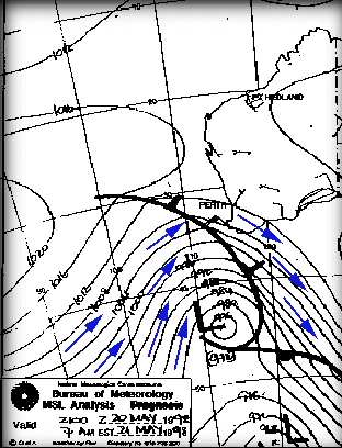
FORECAST TODAY'S MAX: 19 C (67 F) Gale warning current. W/NW winds 30/40kn this morning with possible squalls to 60kn in thunderstorms. Winds tending W/SW 20/30kn by early afternoon and easing to 15/20kn this evening.One of the best things about a cold front is that extra commodity - waves. As any sailor knows, wind generates waves. The more wind, the more waves. If you've experienced a strong cold front, you know that they can get extremely windy, as a consequence the waves can get quite large. Here's another less extreme (for Perth, anyways) cold front. In Perth it blew around 20-30 knots, whilst the south coast received 25-35 knots.
|
|
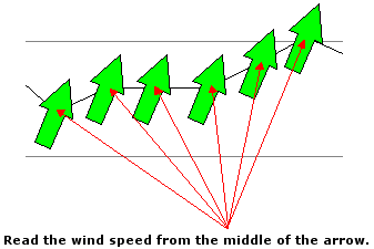
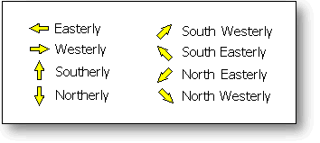
How to read the Wind graphs
|
If you're into a sport that is powered by the wind, or want to avoid windy days then it pays to understand how wind works.
Wind is the movement of air molecules from one location to another. The perfect demonstration of wind is with a fully inflated a car tire. If you open the valve on the car tire, air rushes out. Why? Because there is more air pressure in the tire than there is in the atmosphere, and the atmosphere is always seeking to equalise pressure. Higher pressure pockets of air (i.e. inside the car tire) move to equalise lower pressure areas. So what causes these low pressure areas? Well, in the case of a seabreeze, it's caused by heat...
Cold sinks, heat rises. It's the concept that makes hot air balloons work, and why your vegies are at the bottom of the fridge. During a summer day, the land is heated by the sun, and this heat is absorbed by the surrounding air. Once this air meets a particular temperature, it begins to rise quite rapidly. As a result, a low pressure area is created at ground level. The sea doesn't heat up as quickly as the land, so the air temperature over the water is much less. As a result, this air is free to move sideways to occupy our new low pressure area. The result is a light to gale force wind which rushes in from the sea to fill the lower pressure area left by the hot air rising from the land. Seabreezes usually happen in spring and summer, when the difference in temperature between land and sea is greatest.
Seabreezes are the most amazing phenonenom. For many years I never really paid much attention to the wind. One day, we arrived (late) at the local river to do some water skiing. It was around 1pm, the water was glassy - perfect conditions. Then, me mate Mick says "Here comes the seabreeze...". Looking across the river we could see an approaching line of rough water. And then it hit us full on - the full glory of a 25 knot seabreeze.
What's even more amazing is that the wind can be travelling faster than the front of the seabreeze. It can be progressing inland at 25 km/h, but the actual wind can be blowing at 35 km/h! Sometimes the seabreeze can reach many kilometers inland, and other days it teases you by staying just offshore, coming in, and then going out again.
So to get a seabreeze, it needs to be hot inland. But too hot and you won't get one at all. To explain why this is the case, we need to understand high's and low's and the squiqqly charts they show on the telly called 'Synoptic Charts'.
You need to understand these if you want to have your own guess at what the wind may do. It also assists to understand what the weather man is talking about. Sometimes our local TV weather reports simply say '.. and an afternoon seabreeze'. About as useful as an ashtray on a motorbike.
So check this out:

From the title, it says MSL Analysis. This means it is a Mean (average) Sea Level Analysis. A slice of the atmosphere at sea level. The way the atmosphere changes at different levels is also extremely interesting, but beyond what we talking about here. The numbers indicate the air pressure, called the Barometric pressure. Barometric pressure is measured in hectopascals. Bigger numbers represent greater air pressure. The chart is generated by acquiring a huge number of readings from ships, sea based automatic weather buoys and land based weather stations. These data points are then processed using complex mathamatics to 'best guess' or 'interpolate' values for areas where no reading was available. The meteorologist then sharpens his best HB pencil and draws lines connecting areas of equal pressure (called isobars, or contours), draws a H in the middle of any Highs, and an L in the middle of any Lows. They also draw another chart called a prognosis which is what they estimate to be where the weather will go. It's always valuable to compare the analysis with the prognosis to get an idea of where, and at what speed the weather is travelling.
So high pressure areas rush to fill low pressure areas huh? If that was the case, then you would expect the wind to travel like this:
Bzzzzzzzt. Wrong! These are complex systems, and there's this other forces at work here, plus lets not forget that the world is 3D and this is only a horizontal slice. Wind actually travels pretty much in the direction of the isobar lines. And in the southern hemisphere they trave anti-clockwise around high's and clock wise around lows. And the whole weather pattern moves (generally) in a west to east (left to right) direction. So the wind actually blows around the high cell like this:
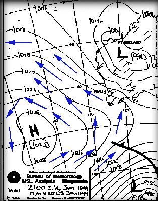
But don't forget. This all gets totally ignored by local wind effects such as seabreezes along the coast in the afternoon.
This synoptic chart is a joy to a wind fanatic living on the coast of Western Australia because this pattern means wind - and lots of it - these cool winds also keep the maximum temperature down. In fact, the forecast for this pattern was:
TODAY'S MAX: 23 C (74 F) Strong Wind Warning current. S/SE winds 20/30kn in the morning, tending S/SW and strengthening to 25/32kn in the afternoon.The S/SE winds in the morning reflect the anti-clockwise direction of wind around the high, untill the afternoon when the thermal induced seabreeze kicks in and changes to an onshore S/SW. Bliss!
But that low cell sitting up in the north is what can ruin it all. These low pressure systems descend in a southerly fashion and bring with them hot and humid conditions. They are called troughs and generally spoil any chance of a seabreeze, as indicated with this chart and forecast:
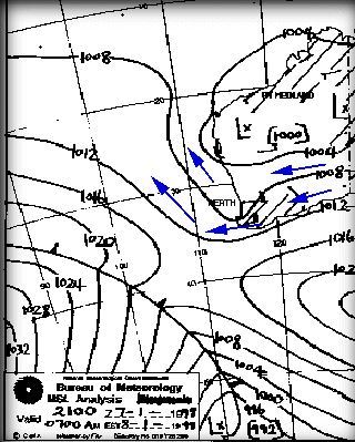
FORECAST: TODAY'S MAX: 35 C (95 F) E/NE winds 15/20kn, easing to 10/15kn by late morning. Winds shifting NW/SW 10/15kn during the afternoon.The capital city of Perth is going to be blasted with E/NE winds in the morning, brought in nice and fresh from the deserts, and these winds are toasty - a maximum of 35 degrees C, and only a mild, if any, seabreeze. But wait - that's a cold front approaching from the south west, and there's a good chance that this will push the trough inland and bring back the seabreezes.
Generally speaking the thing to look for when looking for strong seabreezes is a new high cell aproaching (following a previous high cell), or a tough moving inland and being replaced by a new high (extra windy!).
Well, unlike seabreezes, cold fronts are active mainly during winter and come at any time of day or night. Cold fronts do pass through during the other months, but there effect is usually not noticed by most. Like seabreezes, they come in all sorts of flavours from simply making the sky cloudy to full on roof removing gale force winds. Cold fronts, as the name suggests, is a line of cold air travelling along, generally west to east. As this cold air meets warmer air, the warm air rises, and you guessed, causes the cold air to rush in and fill the space. Thus, the actual 'front' of the front, called the 'squall line' is generally where most of the wind is.
Cold fronts are great when they come through, producing the locally famous 'Norwester'. Because the winds travel clockwise around a low pressure system, the first taste you get is Northerly, but more often than not North Westerly. As the cold front passes through these winds rotate around the compass, going from NW to W to SW, and maybe S. The S part can get quite chilly because it dredging all the cool air from the antartic regions. Not cold by UK standards, but enough to make your face numb. North Westerlies on the otherhand can be quite warm, relative to the usual winter temperatures. The time it takes for the NW to SW transition depends on the speed at which the front is travelling. Usually around a day, sometimes two.
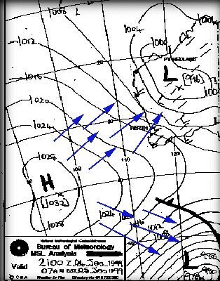
Time to introduce another term - the pressure gradient. In the synoptic charts displayed above, the isobars have been relatively spaced out, because the difference in air pressure is quite small over a large area. When we get a large change in air pressure over a small area - rig up your small sails/kites - it's gonna blow.
Checkout this chart - one of the windiest days in the winter of '98. Blue arrows indicate wind direction. See how close the isobars are together. Also, remember that the entire frontal pattern moves from left to right (west to east), but the winds blow in the direction of the arrows. I hope you can grasp the concept!
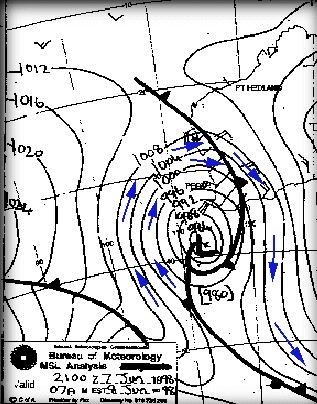
FORECAST TODAY'S MAX: 19 C (67 F) Gale warning current. W/NW winds 30/40kn this morning with possible squalls to 60kn in thunderstorms. Winds tending W/SW 20/30kn by early afternoon and easing to 15/20kn this evening.One of the best things about a cold front is that extra commodity - waves. As any sailor knows, wind generates waves. The more wind, the more waves. If you've experienced a strong cold front, you know that they can get extremely windy, as a consequence the waves can get quite large.
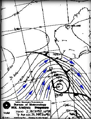
Here's another less extreme (for Perth, anyways) cold front. In Perth it blew around 20-30 knots, whilst the south coast received 25-35 knots.
Summer in Australia lasts from December through to the end of February, with the main windy bit being being December/January. Of course, it can be windy during October to November, there's just more chance of it happening in Dec/Jan. Spring and Autumn are not that windy due to the change of season. Not hot enough for seabreezes, and cold fronts aren't strong enough. (Generally, sort of)
If you come down during winter, then June/July is the peak of winter. Winter really is pot luck for wind. 1 to 2 days per week of winter action might be the norm. Sometimes, if we get a series of cold fronts one after another, it can blow all day and all night for 3 to 4 days.
Many people like to save the graph images for sending to friends, or collecting after a great session.
With the Bitmap images, this was a simple right-click "Save Image as..".
The new HD graph images you can't do this, so here are some options:
Option 1)
Specify you want the "original" bitmap graphs by clicking this link:
www.seabreeze.com.au/weather/settings/bitmap
Option 2)
Use a screen grabbing tool. Windows has a snipping tool , or the Mac Grab tool
The quick fix: If you just want it "fixed", and don't care how or why, click here to restore the old graphs . (Note: this won't work if you use "Incognito" or "Private" " browsing ).
Primarily we've found this to affect some FireFox and Internet Explorer 9, 10 or 11 browsers, or some browers on slow computers.
Why would they be slow, and what changed to make them slow?
We created the new HD (high definition) graphs for two reasons:
1) They are HD - they look much better
2) They are smaller and faster. Literally 1/10th of the size so they use less of your bandwidth and draw quicker. All good so far.
We did extensive testing and found that the new HD graphs crash phones, so we disabled them completely for phones & tablets.
Which leaves laptops & desktop computers. Some FireFox browsers and some versions of Internet Explorer 11 are really slow at drawing them; depending on your actual computer.
So what can you do about it?
Option 1) U se a faster browser. Firefox/IE just don't draw HD graphs very quickly. Chrome and Safari do. We find Chrome is the fastest at most things; certainly this site. You can get Chrome from Google here .
Option 2) Restore the old low-quality graphs by clicking here to pre-select bitmap graph images. If you change your mind and want the HD graphs back, click "Activate HD" at the bottom of the graphs page.
If you use option 2, and you're a fan of "Incognito" or "Private" browsing, then it will revert when you exit your browser (which is the point of incognito browsing). Read down the bottom on how to create a bookmark to make it persist.
Slow rendering on mobiles
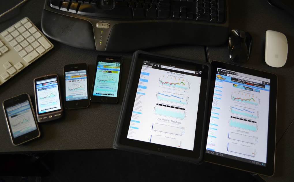
Phone & Tablet browsers have an option to "Request Desktop Site", and when this option is turned on, your phone tells our website it's a big powerful computer, so we give it data for a big powerful computer.
As you can guess, sometimes it can't handle it, so if you're experiencing poor or slow rendering on your mobile, please do check that you have "Request Desktop Site" turned off.
What's the difference between the Bitmaps and the HD graphs?
Bitmaps (like photos) are pre-built on our servers, and delivered directly to your browser, and all browsers render them fast. The main challenge is that creating a really high quality bitmap (e.g. consider somebody with a 4K monitor) it takes a lot of data which means longer download times.
SVG (scalable vector graphics) are a series of drawing instructions - we deliver the drawing instructions and your browser draws them on your computer. Fast, lightweight, and looks great! SVG will draw at premium HD quality regardless of the display size. 200pixels to 4000pixels, as their name suggests, they are "scalable".
Switches for geeks
Adding "/bitmap" to any weather Url will force it to deliver bitmaps.
e.g.
www.seabreeze.com.au/weather/wind-forecast/perth
becomes
www.seabreeze.com.au/weather/wind-forecast/perth/bitmap
Other options include:
Adding "/alwaysBitmap" to any weather Url will force it to deliver bitmaps, and save a setting indicating you always want to see bitmaps.
Adding "/autoFormat" to any weather Url remove the above setting.
Links:
Force Bitmaps: www.seabreeze.com.au/weather/settings/bitmap
Unforce Bitmaps: www.seabreeze.com.au/weather/settings/autoFormat
If you need any further assistance, please do contact us via the Contact link at the bottom of the page.
| Beaufort scale number | Descriptive term | Units in km/h | Units in knots | Description on Land | Description at Sea |
|---|---|---|---|---|---|
| 0 | Calm | 0 | 0 | Smoke rises vertically | Sea like a mirror. |
| 1-3 | Light winds | 19 km/h or less | 10 knots or less | Wind felt on face; leaves rustle; ordinary vanes moved by wind. | Small wavelets, ripples formed but do not break: A glassy appearancemaintained. |
| 4 | Moderate winds | 20 - 29 km/h | 11-16 knots | Raises dust and loose paper; small branches are moved. | Small waves - becoming longer; fairly frequent white horses. |
| 5 | Fresh winds | 30 - 39 km/h | 17-21 knots | Small trees in leaf begin to sway; crested wavelets form on inland waters | Moderate waves, taking a more pronounced long form; many white horses are formed - a chance ofsome spray |
| 6 | Strong winds | 40 - 50 km/h | 22-27 knots | Large branches in motion; whistling heard in telephone wires; umbrellas used withdifficulty. | Large waves begin to form; the white foam crests are more extensive with probably somespray |
| 7 | Near gale | 51 - 62 km/h | 28-33 knots | Whole trees in motion; inconvenience felt when walking against wind. | Sea heaps up and white foam from breaking waves begins to be blown in streaks along direction ofwind. |
| 8 | Gale | 63 - 75 km/h | 34-40 knots | Twigs break off trees; progress generally impeded. | Moderately high waves of greater length; edges of crests begin to break into spindrift; foam isblown in well-marked streaks along the direction of the wind. |
| 9 | Strong gale | 76 - 87 km/h | 41-47 knots | Slight structural damage occurs -roofing dislodged; larger branches break off. | High waves; dense streaks of foam; crests of waves begin to topple, tumble and roll over; spraymay affect visibility. |
| 10 | Storm | 88 - 102 km/h | 48-55 knots | Seldom experienced inland; trees uprooted; considerable structural damage. | Very high waves with long overhanging crests; the resulting foam in great patches is blown indense white streaks; the surface of the sea takes on a white appearance; the tumbling of the seabecomes heavy with visibility affected. |
| 11 | Violent storm | 103 -117 km/h | 56-63 knots | Very rarely experienced - widespread damage | Exceptionally high waves; small and medium sized ships occasionally lost from view behind waves;the sea is completely covered with long white patches of foam; the edges of wave crests are blowninto froth. |
| 12+ | Hurricane | 118 km/h or more | 64 knots or more | The air is filled with foam and spray. Sea completely white with driving spray; visibility veryseriously affected |
| Beaufort scale number | Descriptive term | Units in km/h | Units in knots | Description on Land | Description at Sea |
|---|---|---|---|---|---|
| 0 | Calm | 0 | 0 | Smoke rises vertically | Sea like a mirror. |
| 1-3 | Light winds | 19 km/h or less | 10 knots or less | Wind felt on face; leaves rustle; ordinary vanes moved by wind. | Small wavelets, ripples formed but do not break: A glassy appearance maintained. |
| 4 | Moderate winds | 20 - 29 km/h | 11-16 knots | Raises dust and loose paper; small branches are moved. | Small waves - becoming longer; fairly frequent white horses. |
| 5 | Fresh winds | 30 - 39 km/h | 17-21 knots | Small trees in leaf begin to sway; crested wavelets form on inland waters | Moderate waves, taking a more pronounced long form; many white horses are formed - a chance of some spray |
| 6 | Strong winds | 40 - 50 km/h | 22-27 knots | Large branches in motion; whistling heard in telephone wires; umbrellas used with difficulty. | Large waves begin to form; the white foam crests are more extensive with probably some spray |
| 7 | Near gale | 51 - 62 km/h | 28-33 knots | Whole trees in motion; inconvenience felt when walking against wind. | Sea heaps up and white foam from breaking waves begins to be blown in streaks along direction of wind. |
| 8 | Gale | 63 - 75 km/h | 34-40 knots | Twigs break off trees; progress generally impeded. | Moderately high waves of greater length; edges of crests begin to break into spin drift; foam is blown in well-marked streaks along the direction of the wind. |
| 9 | Strong gale | 76 - 87 km/h | 41-47 knots | Slight structural damage occurs -roofing dislodged; larger branches break off. | High waves; dense streaks of foam; crests of waves begin to topple, tumble and roll over; spray may affect visibility. |
| 10 | Storm | 88 - 102 km/h | 48-55 knots | Seldom experienced inland; trees uprooted; considerable structural damage. | Very high waves with long overhanging crests; the resulting foam in great patches is blown in dense white streaks; the surface of the sea takes on a white appearance; the tumbling of the sea becomes heavy with visibility affected. |
| 11 | Violent storm | 103 -117 km/h | 56-63 knots | Very rarely experienced - widespread damage | Exceptionally high waves; small and medium sized ships occasionally lost from view behind waves;the sea is completely covered with long white patches of foam; the edges of wave crests are blown into froth. |
| 12+ | Hurricane | 118 km/h or more | 64 knots or more | The air is filled with foam and spray. Sea completely white with driving spray; visibility very seriously affected |

 Click this and it will alert the moderators of the post. If a moderator is online at the time, they will investigate, otherwise, next time one logs on they'll have a look. Please be patient.
If you disagree strongly with the content, but would rather leave the censoring to the moderators, maybe use the thumbs
Click this and it will alert the moderators of the post. If a moderator is online at the time, they will investigate, otherwise, next time one logs on they'll have a look. Please be patient.
If you disagree strongly with the content, but would rather leave the censoring to the moderators, maybe use the thumbs


 to cast your vote against it.
Rest assured both methods will not reveal your actions, and we will not contact you in regards to reports or votes.
The goal of the forums is to keep it a fantastic place to visit, and with your help / feedback we can keep it that way!
to cast your vote against it.
Rest assured both methods will not reveal your actions, and we will not contact you in regards to reports or votes.
The goal of the forums is to keep it a fantastic place to visit, and with your help / feedback we can keep it that way!
Why does this place even exist?

These forums are here to create a meeting place for people who care about our sports. We want to improve, we want to know how to fix gear, how to use the gear, the best conditions, where those conditions are, what gear works best where .. and of course, we all want to meet people with similar interests.
In this environment, people are friendly and helpful to each other. We all stand on each others shoulders to reach higher, achieve more and have more fun.
Our sport is our recreation. It's what we do for fun - it's not about getting all serious and upset, there's enough of that in the stuff we do for money.
For years, the forums have been, and continue to be a success - friendships have been made, meetings on the beach organised, events attended, accomodation offered to travelling members, beaches saved through petitions, territorial disputes settled pages of shared knowledge created, and so much more.
It aint' always blue sky...
Occasionally, a post or topic with inappropriate content will appear. It may stay online longer than it should while we get to it. Whilst this is happening we appreciate your patience. We appreciate you taking the time to let us know via the voting mechanisms explained later.
Please understand that our moderators are not pyschic or even online 24 hours per day, 7 days a week, so there will always be the possibility that inappropriate content will be viewable longer that we would all hope.
There will be members who are different and post questionable content. Why?
Maybe they are drunk, tired and/or emotional?
Maybe they're stressed and are not being themselves?
Maybe they feel anonymous and believe they won't be caught out?
Perhaps they're blunt, direct or simply rub you up the wrong way?
Perhaps they're injured and frustrated?
Perhaps there is an issue that's 'emotionally loaded' for them?
They might enjoy stirring others up?
...or it could just be the way they are all the time!
It's for these situations that rules are needed.
It's for these situations that moderators are needed.
Unfortunate ... but to be expected .. it's part of the territory.
Tips to handle posts that upset you.
Seek to understand before seeking to be understood.
Could there be a slightest weeniest smallest possibility that you may have made an error? Unbelievable as it may sound, some of us do make mistakes!
Basic Rule: Have the courage to step away. Go do something different before getting all fired up on the keyboard.
General Netiquette
* Avoid Sarcasm and dry humour. It does not work with the written word. Putting a smiley after a nasty piece of text doesn't fix it.
* Disagree? - discuss the subject, not the person. If you goal is to win them over to your point of view, provide evidence why your point of view is worthwhile adopting. Be constructive and forward moving.
* Make topic titles interesting - they make or break whether your post gets read.
* A large audience will see your post, and your words may come back to haunt you. This audience may potentially include past, present and future employers, staff at your place of study, friends, family, etc. And unlike the spoken word, your written posts will exist here for a long time.
* If you are responding to someone else's comments, try to include a quote or summary of their post, to provide context to other readers. Quoting more than 10 lines is a bit much.
* If you want to take a topic offline and write a personal response, please use the "Private Message" facility - an Email button is available on each post, or by clicking on the members name.
* Do not start or perpetuate flame wars. If someone insults or attacks you, do not respond in kind - because "they started it" is an incredibly lame argument
* DON'T USE OTHERS BEHAVIOUR AS AN EXCUSE FOR YOUR BEHAVIOUR. If we had a dollar for each person who wrote in " how come I can't do it when so and so is doing it? " There are plenty of reasons, the point is, just because you see someone else breaking the rules does not give you the right to break them and use others actions as your justification.
Racism, Sexism, Ageism and Religious Intolerance and Vilification
Smarty Pants Swearing
Moderation of Foul Language
Offensive Websites
When this occurs, the poster is usually quite fired up and emotional. Often the customer is now out to cause as much damage as possible to the business with the mission that they are "fully justified" (their words) and "simply stating facts" (their words) about the business/association.
This may be the case .. or not. There are many sides to any story. The point is that the Seabreeze forums are not the appropriate place to resolve the issue. Go to the appropriate legal/government authority and do it there.
Choose not to, and end up in hot water. As soon as you flame a business, you'll usually get supporters of the business come out in defence and question your behaviour and motives. People interested in the discussion will seek more information from you. It soon descends into an argument containing many and varied versions of the truth and everybody goes home unhappy.
It has never ended well for anybody.
The business is damaged, the poster now has a stigma in the forum community (and now can't deal with many shops because the shops know what will happen if they cross this customer - their business will get dragged through the mud.)
And of course, there's also the situation when the poster does not really have a complaint, but is simply a competitor or naive associate of a business who thinks the way to get more business is to degrade the competition.
A special note: This applies (and has been applied) to any business, not just businesses that sponsor the site.
In this case the poster has discovered he can buy an item overseas cheaper than in a shop here in Australia. Now they want to share this with everybody, and also want to infer that because the price is different that "Australian businesses are ripping us all off".
Posts of this nature will be locked/or removed as they always stir up bad vibes and arguments. Like clockwork, pro-shop crew come out versus the anti-shop crew, and it's on, and has never ended well. Ends up being just a bunch of angry people arguing over a $100 difference. It's not been worth it, and everybody goes home unhappy, so we nip it in the bud before it starts.
For Sale and Wanted to Buy
Some forum members are site sponsors, you'll see a "Site Sponsor" link under their name. These members have purchased banner advertising which they use to display their brand and make offers about products and services they have available.
These businesses are essential to keeping Seabreeze online. Our forums are the discussion zone of a highly competitive industry, and we do our best to enable sponsors to have a say and discuss things of interest while maintaining a fair environment for all. It can be hard for sponsors to have a say, as there are people waiting in the wings to provide commentary on their posts.
Therefore we ask that all businesses:
* Use the News system for product announcements
* Use the Events system for demo days
* Do not post links to their website,
* Do not post prices, price lists, sale brochures, bargains, "stock clearance" etc.
* Do not post competitions/links to competitions/promo days
All of these things are can be performed through the banner, the News system or the Events system. If these don't suit, please contact us to discuss alternative solutions.
There will be times when a member is explicitly asking where to purchase an item, or for specific product information, and in these situations its ok for sponsors to provide answers.
When sponsors do post, we ask that you give them some latitude. If you're concerned that a sponsor may be ruining your experience of the forums, please contact us first, rather than flaming the poster.
If we find businesses, associates/team riders of businesses flaming, degrading other businesses/products, moderation and possibly immediate banning will result.
Not a site sponsor, but want to promote your goodies?
You'll find your local council has laws saying that it's illegal for you to stick posters and advertising on council property - "Bill posters will be prosecuted". Most businesses accept this and don't put their posters and stickers all over signs, traffic lights, bridges, tunnels, etc.
Same here - please do not plaster your adverts/promos in/around the site - please contact us via the feedback page to find out how we can work out together to find a solution for you.
If you see another business advertising, this is not a valid excuse for you to do so. Do you steal because someone does?
Using Seabreeze to advertise other sites (be it your own site, or that of a friend, etc), is not acceptable. Posting about such sites or sending unsolicited PM's about such sites is unacceptable.
Please note that Seabreeze members are a highly suspicious lot who can smell advertising a mile away, so if there is even a hint that your post is just poorly disguised advertising, be prepared to have your post removed and/or for the linked site to be torn to pieces from a review perspective.
Inappropriate posting of business advertising will be removed.
There is also the reverse, where people getting financial reward from a competing product ask leading questions of a competitors products to make it look bad in the hope that it will make their product more appealing. These people go out of their way to directly highlight flaws, or, on occasion, even invent flaws and myths.
It's not illegal, is usually see-through, and can result in angry feelings by those who believed the mystery posters were "ordinary customers". It is particularly dissappointing when these people take time out to degrade competitors and/or competing products via single line posts such as "You wouldn't catch me buying that." type of comment.
These activites are directly against the forum rules and counts as spam.
The common name for such a member (who indirectly promotes their own product) is a Pimp.
If you suspect a member of being a pimp, please let the moderators know, as targeting them is against the rules and makes you subject to moderation (which was not your intent!)
Please refrain from making accusations against companies or individuals within the forums.
Note that occasional positive comments from known members have never been a problem.
Yay! You've got so excited about your sport, that you've gone and created a new facebook group. You're keen to spread the word, and get as many "Likes" as you can .. there's something new!
Pretty much every other week, some enterprising soul does the above, and enthusiastically enters the forums and posts away about how everybody should join their new facebook group, because it's new, and we can share stuff, and it's great, and we can talk, and we can share photos, and ... and .. and ... ummm .. sorry to interrupt your flow of passion, but isn't that what the forums are all about?
Take a breather and realise that you're going to look a bit silly. Everybody here is already having a great chat, and you coming in and telling everybody that they should be chatting somewhere else in an empty room you've just "created" may look a bit silly.
People have been sharing and helping each other in the Seabreeze forums since before facebook was started, so do yourself a favour and get involved locally - contribute, not dilute. Help make the forums are better place, don't tell everybody to go to your "took 30 seconds to create New Social Group", it's embarrassing!
As one person put it, it's like walking into a pub, and yelling out "Hey everybody! A new American pub has opened down the road, and I just booked a table - everybody come with me .. and tell all your friends too!!" .. poor form!
Crossposting
Posting the same Topic in more than one forum Category is not appropriate. If you can't decide which forum to post it a particular Topic in, just choose the one that most closely matches and see how you go. If you don't think you are getting the right answers, ask a moderator to move the Topic to a more appropriate location at some later point.
Please note that posting new Topics in multiple forums saying "Come look at Topic <insert link here>" is not permitted, and is also considered crossposting.
Duplicates
Off-topic
Off-topic Topics

Moderators have task of monitoring the content of the forums. They aim to read all topics and posts and make assessments on what is and isn't appropriate. Did you know that Moderators are real people? They suffer from late nights, emotional issues (good & bad), and can often speed read topics. What this means is that they aren't some automated perfect computer program that makes the right call every time.
Moderators can delete posts, delete topics, move topics, modify topic titles, close topics to prevent further discussion and remove offensive language from posts.
Moderation is a very "grey" area. For example, a group of 16 year olds who have started their own topic may be having a friendly banter amongst each other, whereas to others to reads like a full on argument.
Alerting the Moderators of inappropriate content
Above each post is a voting system of thumbs up and thumbs down. Simply place your vote to indicate if the post should be pulled.
You'll often see voted posts remaining, competitors often vote other businesses/products down. It may have a large number of thumbs up and thumbs down.
The important thing is that all posts that have a thumbs down indicator are investigated by the moderators. With buckets of new posts entering the system every day, it makes it easy for the moderators to zoom in on inappropriate posts as voted by the forum users. Allow the moderators time to respond. If you're all stirred up about a post, this doesn't mean that a moderator is sitting around awaiting your report so it can be investigated.
Post Deletion Policy
Topic Deletion Policy
Topic Closure Policy
If a member chooses to continue to create duplicate logins, and abuse our hospitality, be warned that we will not hesitate to report your breaches to your ISP's abuse department. As almost all ISP "Acceptable Usage Policies" include clauses regarding member behaviour on websites, such a report can result in a warning from your ISP and potentially the termination of your ISP account.


|
 in member profiles, the forums, the photo gallery and many other spots.
Much like any classifieds listing service, we publish adverts, and are unable to certify the validity of sellers, or buyers. However there are some things you can do to make it safer:
Check their profile:
- how long have they been registered on the site
Make verbal contact:
- in this age of email, you can still use your personal skills to talk with the person via phone to verify details and see what kind of character they are.
Establish expectations:
- is the seller/buyer an offshore worker who dissappears for two-three weeks at a time and doesn't access his email?
Do they only check their email once a fortnight? Are they computer literate? No point getting all upset about no email reply for reasons you could have worked out beforehand..
Delivery options:
- Does the buyer pay, and then the seller ships, or the seller ships & the buyer pays on receipt? You'll need to sort this out upfront.
** Remember that Australia Post at most will refund you $100 if they lose your package. i.e. You can register it for delivery, but if it doesn't roll up (i.e. they lose it), the most they'll give you is $100. Not much consolation for your $1000 package. A hard lesson to learn.
* * PayPal have all sorts of caveats about "refunds", so make sure you understand their policy, as you're more than likely not covered. A hard lesson to learn.
** COD (cash on delivery) is a great option - recipient pays upon receipt of goods. Australia Post is a massive service. In our experience via this site of shipping goods for 3 years, they very rarely lose things, but it can & does happen - be prepared for it, and be prepared for a 2-3 week wait whilst they investigate.
The wheels turn slowly. Insurance for $15 sounds expensive when you're standing at the counter, but is may well worth it should it go wrong.
Doing interstate deals really does come down to you speaking with the seller, getting as many photos as possible and trusting/taking the risk accordingly.
www.fastway.com.au www.packsend.com.au www.smartsend.com.au www.rpmfreight.com(These are example links, not recommendations of businesses we have used)
Can't find what you're looking for? Send us a message and we'll get back to you.

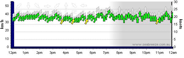
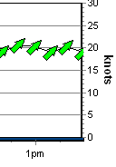 Green Arrows indicate Strong wind, which is 18+ knots, 30+ Km/H, Force 5 or
more.
This graph shows an 18 to 20 knot southwester around 1pm
Green Arrows indicate Strong wind, which is 18+ knots, 30+ Km/H, Force 5 or
more.
This graph shows an 18 to 20 knot southwester around 1pm
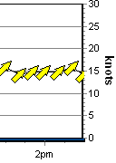 Yellow Arrows indicate Moderate wind, which is 12-18 knots, 20-29 Km/H,
Force 4.
This graphs shows a 14 to 16 knot southwester around 2pm
Yellow Arrows indicate Moderate wind, which is 12-18 knots, 20-29 Km/H,
Force 4.
This graphs shows a 14 to 16 knot southwester around 2pm
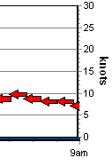 Red Arrows indicate Light/No wind, which is 0-12 knots, 0-19 Km/H, Force 3 or
less.
A 7 to 9 knot easterly around 8-9am
Red Arrows indicate Light/No wind, which is 0-12 knots, 0-19 Km/H, Force 3 or
less.
A 7 to 9 knot easterly around 8-9am


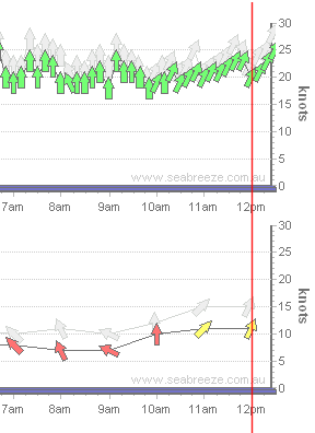
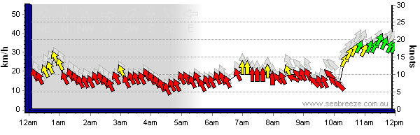 In the graph above, you can see the seabreeze arriving at 10:30 am where it shifts from a SE to a SSW.
The graph below is 8pm later the same day, and shows the previous 12 hours to 8am.
The grey gradient at the left indicates night is approaching (sunset was 7:32pm)
In the graph above, you can see the seabreeze arriving at 10:30 am where it shifts from a SE to a SSW.
The graph below is 8pm later the same day, and shows the previous 12 hours to 8am.
The grey gradient at the left indicates night is approaching (sunset was 7:32pm)
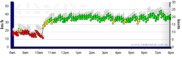 This particular day was an amazingly consistent 20 knot southwester which continued right through past midnight...interesting
change of direction from SSW to S once the sun went down...
This particular day was an amazingly consistent 20 knot southwester which continued right through past midnight...interesting
change of direction from SSW to S once the sun went down...