Cyclone Narelle: Cat 4 threat to Cape York
Quick Summary
Tropical Cyclone Narelle is a Category 2 system in the northern Coral Sea, forecast to intensify to Category 4 before striking far northeast Queensland between Lockhart River and Port Douglas on Friday.
Destructive gusts exceeding 200 km/h are possible near the centre at peak intensity. A Cyclone Watch is in effect from Lockhart River to Port Douglas and adjacent inland areas.
What you need to do now
Boaters and fishers in north Queensland should secure or haul vessels immediately — soils are saturated, rivers are running high, and conditions will deteriorate rapidly from Thursday.
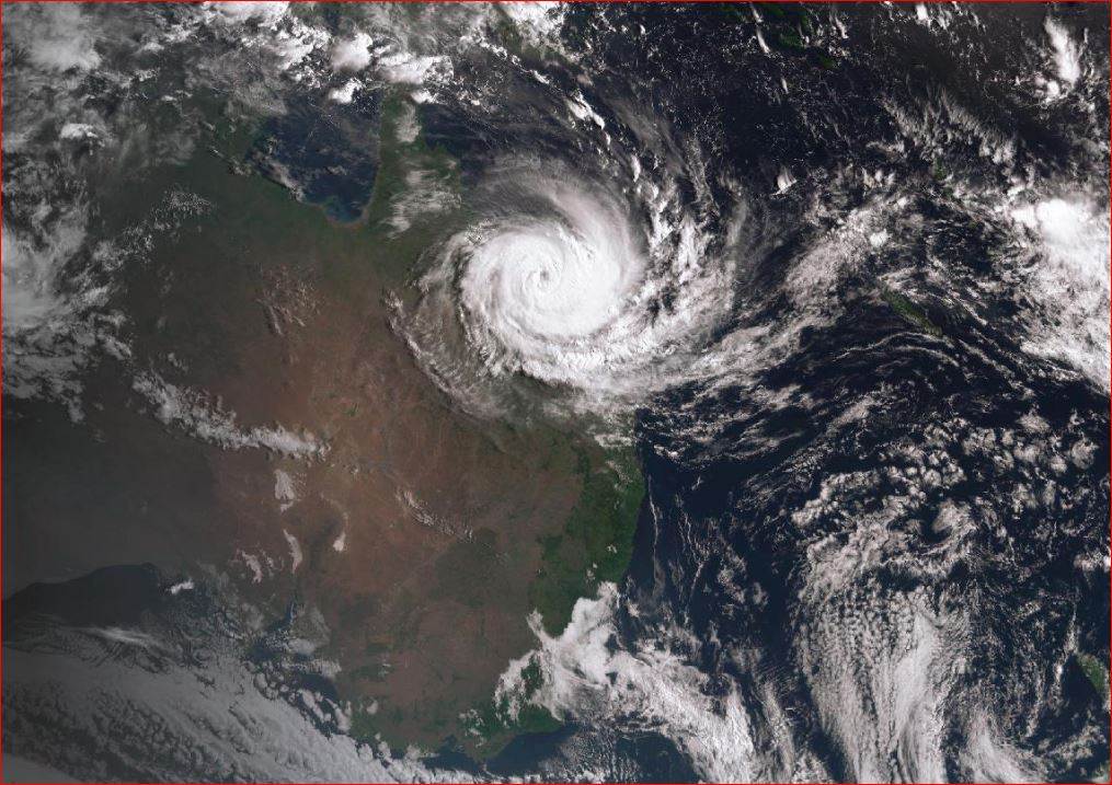
Tropical Cyclone Narelle is closing in on far north Queensland. As of 4:00 am AEST Wednesday 18 March, the Bureau of Meteorology (BOM) placed Narelle approximately 660 km northeast of Willis Island and 1,050 km east-northeast of Cooktown, moving west-northwest at 18 km/h with sustained winds of 110 km/h and gusts reaching 155 km/h, according to BOM's tropical cyclone forecast track map (IDQ65002). The system was a Category 2 at that update. It is expected to reach Category 3 intensity by Thursday and Category 4 by Friday, before approaching the coast between Lockhart River and Port Douglas late this week.
The atmospheric setup driving Narelle
A subtropical ridge sitting south of Queensland is the steering mechanism. That ridge is funnelling Narelle steadily westward on a direct track toward Cape York Peninsula. What makes this system more potent than its current category suggests is what's sitting beneath it: sea surface temperatures in the northern Coral Sea are running up to 3°C above the 1961–1990 climatological average, according to BOM's weekly SST analysis for the week ending 8 March 2026. Warm upper ocean water is the primary fuel source for tropical cyclones, and Narelle has an unusually deep reservoir to draw from as it intensifies.
The 2025–26 La Niña is winding down, with the Niño 3.4 sea surface temperature index sitting at −0.67°C as of 1 March 2026, according to BOM's ENSO Outlook. That might suggest the season's worst is over — but the elevated SSTs along Queensland's east coast tell a different story. La Niña may be easing, but it has left behind warm, energy-laden waters that can still sustain and intensify a system like Narelle. The combination of a weakening La Niña pattern and anomalously warm coastal waters is what separates Narelle from a typical late-season cyclone.
The ground beneath is already saturated. As BOM Senior Meteorologist Angus Hines noted this week: "We've seen frequent bouts of wet weather across both the north and interior of Queensland in recent months, and there's a really prolonged, ongoing flood situation across much of the state. We've got rivers running extremely high at the moment." Major Flood Warnings are currently active for the Thomson River and Cooper Creek, and Severe Weather Warnings cover parts of the Channel Country Forecast District. When Narelle's rainfall arrives over already-maxed catchments, river responses will be rapid and potentially extreme.
Forecast track, timing and wind hazards
The watch zone currently spans Lockhart River to Port Douglas and adjacent inland areas, with no Warning Zone declared as of Wednesday morning. That will change. The BOM's track forecast has Narelle approaching the coast in the Lockhart River to Port Douglas corridor. The timing breakdown, according to BOM's tropical cyclone advice:
- From early Thursday: Damaging gusts to 120 km/h (75 mph) possible between Cape Melville and Port Douglas
- From Thursday night: Destructive gusts to 155 km/h (96 mph) possible between Coen and Cooktown
- From Thursday evening through Friday: Heavy rainfall with flash flooding likely between Cape Melville and Port Douglas, extending inland
- At peak Category 4 intensity: Very destructive gusts exceeding 200 km/h (124 mph) possible near the centre
BOM meteorologist Robert Urbaniak confirmed the wind threat extends well south of the landfall zone. Destructive wind gusts could hit Cape York from Lockhart River to Cooktown on Thursday, with heavy rainfall across the region down to Port Douglas and Cairns, Urbaniak said in briefing materials published this week. Tides will run higher than normal between Coen and Port Douglas throughout the passage of the system.
"We've got rivers running extremely high at the moment." — Angus Hines, Bureau of Meteorology Senior Meteorologist
After crossing the Cape York Peninsula, Narelle is expected to weaken while traversing the land mass before emerging over the Gulf of Carpentaria. Environmental conditions over the Gulf remain favourable for re-intensification, according to BOM modelling, raising the prospect of a subsequent landfall along the Northern Territory coast early next week. Residents in the Gulf country, Darwin, and the NT's Top End should also be monitoring the system's progress.
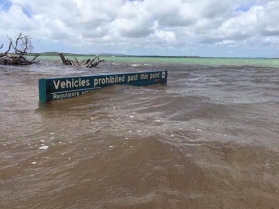
 Image supplied by Stubbies
 What this means if you're on the water in north Queensland
If your vessel is anywhere between Cooktown and Port Douglas, act now — not Thursday morning. The Daintree, Mossman, and Bloomfield rivers are already running high after last weekend's rainfall. Dean Clapp, owner of Crocodile Express tour operations on the Daintree River, has already experienced what unsecured vessels face in these conditions. During flooding earlier this month, one of his boats — the Jungle King — was washed approximately 20 km down the Daintree River and out onto the Great Barrier Reef. "Anything that's not properly secured could go missing," Clapp told media this week. The boat was recovered, but Clapp estimates the damage bill at $100,000. That's a before-the-cyclone flood event. Narelle's storm surge, combined with swollen rivers and a potential Category 4 landfall, creates layered risk that Clapp's experience illustrates starkly.
Boat ramp and marina access will shut down well before landfall. Maritime Safety Queensland protocols require all vessels to be secured, hauled, or relocated before a Warning Zone is declared. For boats in the Cairns region — which falls south of the current Watch Zone but within the heavy rainfall and elevated tide risk area — the window to move is Wednesday. Once a Watch upgrades to a Warning, hardstand facilities and cyclone moorings fill fast. Cooktown Harbour, Cairns Marlin Marina, and Port Douglas Marina are the primary options; all will be managing cyclone preparations simultaneously. Divers with equipment staged on boats should retrieve it now. The same applies to any fishing charter operators who've been targeting reef and estuary species in the Watch Zone.
Offshore fishing across the Coral Sea is off the table this week. BOM has issued Marine Wind Warnings for multiple ocean areas associated with Narelle's circulation, and conditions offshore will be severe well beyond the coastal impact zone. Surfers monitoring swell from the system should note that east-to-northeast swell will build ahead of the cyclone's approach — but coastal entry points north of Cairns will face hazardous rip conditions, amplified by wind-against-tide scenarios as the surge moves through. Do not attempt to access the coast in the Watch Zone from Thursday onwards.
The broader picture: a season already testing the far north
Narelle arrives as far north Queensland's flood toll is already severe. Graziers in the Gulf Country have lost an estimated 100,000 livestock from January flooding alone, according to SBS News. Infrastructure damage from successive flood events this season runs across central and eastern Queensland. The addition of a Category 4 landfall on saturated soils — particularly in the mountainous terrain around Cairns and the Atherton Tablelands — creates conditions where flood responses in tributaries of the Daintree, Mulgrave, and Johnstone river systems could exceed anything seen earlier in the season. The Burnett River at Bundaberg had already been forecast to approach December 2010 flood levels from earlier events this month; catchments in Narelle's direct path have far less buffer capacity than they would in a normal season.
The non-obvious hazard here is timing. Cyclone warnings generate focus on wind and storm surge, but the flooding aftermath often carries greater cumulative risk — particularly for anyone attempting to return to damaged vessels or coastal access points after the system passes. Harbour masters and maritime authorities will not clear vessel access until formal all-clears are issued. After Cyclone Koji in January, some north Queensland boat ramps remained closed for more than a week after the system's passage due to debris and channel shoaling. Narelle's rainfall totals, falling on already-full catchments, will likely extend that kind of disruption timeline.
Key questions answered
What category will Narelle be at landfall?
BOM's forecast has Narelle reaching Category 3 by Thursday and Category 4 by Friday, with very destructive gusts exceeding 200 km/h possible near the centre. Exact intensity at landfall depends on the track and timing of coastal interaction. Forecast uncertainty increases at longer lead times, and the situation should be treated as a severe cyclone event regardless of the precise category at the moment of crossing.
Is Cairns in the Warning Zone?
As of Wednesday 18 March, no Warning Zone has been declared. The current Watch Zone runs from Lockhart River to Port Douglas. Cairns sits just south of the Watch Zone boundary, but falls within the heavy rainfall, elevated tide, and potential gale-wind risk area. Residents and boaters in Cairns should treat the situation as a serious threat and complete preparations now.
What happens to Narelle after it crosses Queensland?
After weakening over Cape York Peninsula, the system is expected to emerge over the Gulf of Carpentaria, where warm waters and favourable atmospheric conditions could allow re-intensification before a second landfall on the Northern Territory coast. Residents in Gulf Country communities, Darwin, and the NT's Top End should monitor BOM updates through the coming days.
When will conditions improve?
The most intense conditions are forecast for Thursday night through Saturday in the direct landfall zone. Rainfall impacts across a broader area — including catchments south of Cairns — may persist well into next week as the system tracks westward and eventually into the NT.
Where can I monitor active warnings?
Seabreeze publishes active marine and coastal warnings at seabreeze.com.au/warnings, updated as the BOM issues new advice. For the latest marine forecast for your area, check Seabreeze marine forecasts — particularly relevant for anyone managing a vessel in or around the Watch Zone.