Weather Situation for Victoria
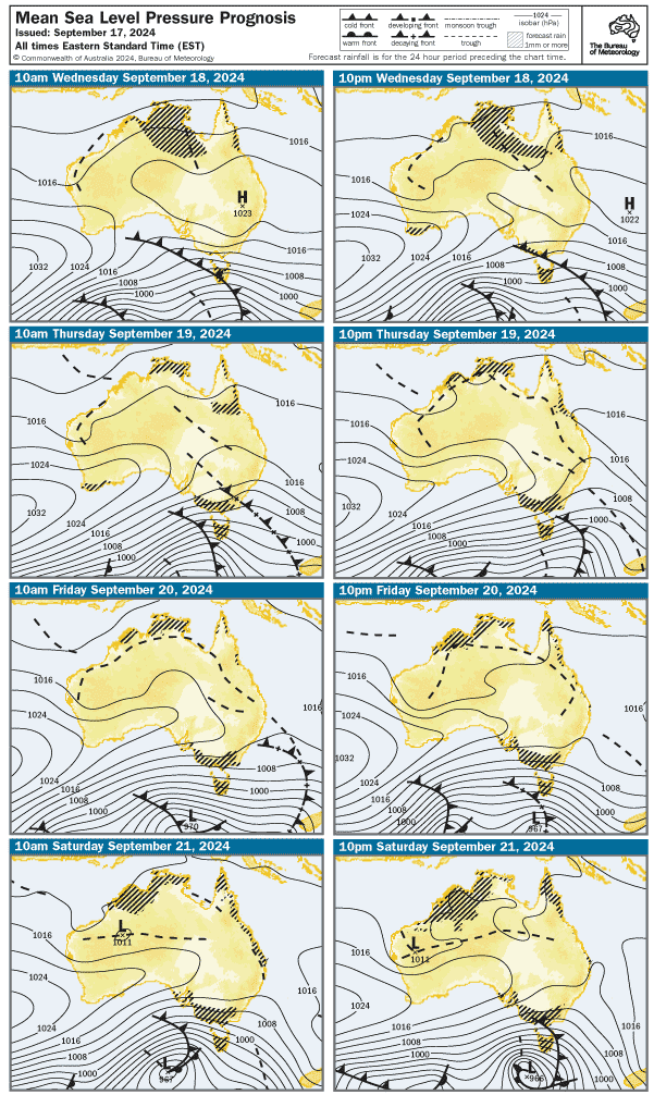
A high to the west of the state will drift northeastwards to settle over southern NSW during today, extending a broad ridge over Victoria. A cold front is expected to reach western Bass Strait on Wednesday afternoon crossing the remainder of the coastal waters overnight into early Thursday. Another cold front follows on Thursday afternoon, moving east through Bass Strait.
Weather Situation for Gippsland Lakes
A high to the west of the state will drift northeastwards to settle over southern NSW during today, extending a broad ridge over Victoria. A cold front is expected to reach western Bass Strait on Wednesday afternoon crossing the Lakes overnight. Another cold front follows on Thursday, moving over the Lakes late in the day.
Weather Situation for Port Phillip and Western Port
A high to the west of the state will drift northeastwards to settle over southern NSW during today, extending a broad ridge over Victoria. A cold front is expected to reach western Bass Strait on Wednesday afternoon crossing the Bays overnight. Another cold front follows on Thursday, moving over the Bays in the evening.
Port Phillip Forecast
Local Waters Forecast for Port Phillip
Issued: Tuesday, 17 September 5:10AM
Forecast for Tuesday, 17 September
Winds: Westerly 15 to 20 knots turning northwesterly 10 to 15 knots in the evening.
Seas: Around 1 metre.
Swell:
Weather: Cloudy.
Forecast for Wednesday, 18 September
Winds: Northwesterly 15 to 25 knots turning westerly in the early evening then easing to 15 to 20 knots in the late evening.
Seas: Around 1 metre, increasing to 1 to 1.5 metres during the morning.
Swell:
Weather: Partly cloudy. 60% chance of showers.
Forecast for Thursday, 19 September
Winds: Westerly 20 to 30 knots.
Seas: Around 1 metre, increasing to 1 to 1.5 metres during the morning.
Swell:
Weather: Partly cloudy. 80% chance of showers.
Forecast for Friday, 20 September
Winds: Westerly 15 to 20 knots turning northwesterly 15 to 25 knots during the morning.
Seas: 1 to 1.5 metres.
Swell:
Weather: Cloudy. 70% chance of showers.
Western Port Forecast
Local Waters Forecast for Western Port
Issued: Tuesday, 17 September 5:10AM
Forecast for Tuesday, 17 September
Winds: West to northwesterly 10 to 15 knots, reaching up to 20 knots west of Sandy Point.
Seas: Below 1 metre, increasing to 1 to 1.5 metres west of Sandy Point.
Swell:
Weather: Cloudy.
Forecast for Wednesday, 18 September
Winds: Northwesterly 15 to 25 knots turning westerly 15 to 20 knots in the late evening.
Seas: Around 1 metre, increasing to 1 to 1.5 metres west of Sandy Point during the morning.
Swell:
Weather: Partly cloudy. 70% chance of showers.
Forecast for Thursday, 19 September
Winds: Westerly 20 to 30 knots.
Seas: Around 1 metre, increasing to 1 to 1.5 metres during the afternoon.
Swell:
Weather: Cloudy. 90% chance of showers.
Forecast for Friday, 20 September
Winds: Westerly 15 to 20 knots turning northwesterly during the morning.
Seas: Below 1 metre, increasing to 1 to 2 metres west of Sandy Point.
Swell:
Weather: Cloudy. 80% chance of showers.
Gippsland Lakes Forecast
Local Waters Forecast for Gippsland Lakes
Issued: Tuesday, 17 September 5:10AM
Forecast for Tuesday, 17 September
Winds: Westerly 10 to 15 knots increasing to 15 to 20 knots in the late morning then decreasing to 10 to 15 knots in the evening. Winds tending southwesterly during the afternoon.
Swell:
Weather: Partly cloudy.
Forecast for Wednesday, 18 September
Winds: West to northwesterly about 10 knots increasing to 15 to 20 knots in the morning.
Swell:
Weather: Sunny.
Forecast for Thursday, 19 September
Winds: Westerly 15 to 25 knots.
Swell:
Weather: Partly cloudy. 70% chance of showers.
Forecast for Friday, 20 September
Winds: Westerly 15 to 20 knots turning northwesterly 10 to 15 knots during the evening.
Swell:
Weather: Cloudy. 50% chance of showers.
Port Phillip and Western Port Forecast
Local Waters Forecast for Port Phillip and Western Port
Issued: Tuesday, 17 September 5:10AM
Weather Situation for Victoria
A high to the west of the state will drift northeastwards to settle over southern NSW during today, extending a broad ridge over Victoria. A cold front is expected to reach western Bass Strait on Wednesday afternoon crossing the remainder of the coastal waters overnight into early Thursday. Another cold front follows on Thursday afternoon, moving east through Bass Strait.
West Coast: SA-VIC Border to Cape Otway Forecast
Local Waters Forecast for West Coast: SA-VIC Border to Cape Otway
Issued: Tuesday, 17 September 5:10AM
Forecast for Tuesday, 17 September
Winds: Westerly 15 to 25 knots, becoming west to northwesterly 20 to 30 knots in the late morning.
Seas: 1 to 1.5 metres, increasing to 1.5 to 2.5 metres during the morning.
Swell: Southwesterly 3 metres.
Weather: Cloudy. 60% chance of showers.
Forecast for Wednesday, 18 September
Winds: Northwesterly 25 to 30 knots, reaching up to 35 knots offshore in the late morning and early afternoon. Winds turning west to southwesterly 20 to 25 knots in the early evening.
Seas: 2 to 3 metres.
Swell: Southwesterly 3 to 4 metres, tending westerly 4 to 5 metres during the morning, then tending west to southwesterly 4 metres by early evening.
Weather: Partly cloudy. 95% chance of showers.
Forecast for Thursday, 19 September
Winds: Westerly 25 to 35 knots.
Seas: 1.5 to 2.5 metres, increasing to 2.5 to 4 metres during the morning.
Swell: West to southwesterly 4 to 7 metres.
Weather: Cloudy. 90% chance of showers.
Central Coast: Cape Otway to Wilsons Promontory Forecast
Local Waters Forecast for Central Coast: Cape Otway to Wilsons Promontory
Issued: Tuesday, 17 September 5:10AM
Forecast for Tuesday, 17 September
Winds: Westerly 15 to 25 knots, increasing to 20 to 30 knots in the morning. Winds turning northwesterly in the late evening.
Seas: 1.5 to 2 metres, increasing to 2 to 3 metres around midday.
Swell: Southwesterly 1.5 to 2 metres, increasing to 2 to 3 metres in the west.
Weather: Cloudy. 60% chance of showers.
Forecast for Wednesday, 18 September
Winds: Northwesterly 20 to 30 knots, reaching up to 35 knots in the south in the late morning and afternoon. Winds turning west to southwesterly in the evening, easing to 15 to 25 knots in the late evening.
Seas: 2 to 3 metres, increasing to 2.5 to 4 metres in the east during the morning.
Swell: West to southwesterly 2 to 3 metres, increasing to 2.5 to 4 metres in the west.
Weather: Partly cloudy. 95% chance of showers.
Forecast for Thursday, 19 September
Winds: Westerly 20 to 30 knots increasing to 25 to 40 knots in the morning.
Seas: 1.5 to 2.5 metres, increasing to 3 to 4 metres during the afternoon.
Swell: West to southwesterly 2 to 3 metres, increasing to 4 to 6 metres during the afternoon.
Weather: Cloudy. 95% chance of showers, with possible small hail in the evening.
Central Gippsland Coast: Wilsons Promontory to Lakes Entrance Forecast
Local Waters Forecast for Central Gippsland Coast: Wilsons Promontory to Lakes Entrance
Issued: Tuesday, 17 September 5:10AM
Forecast for Tuesday, 17 September
Winds: Westerly 20 to 25 knots increasing to 20 to 30 knots in the morning.
Seas: 1.5 to 2 metres, increasing to 2 to 3 metres during the morning.
Swell: West to southwesterly around 1 metre inshore, increasing to 1 to 2 metres offshore.
Weather: Cloudy. 60% chance of showers.
Forecast for Wednesday, 18 September
Winds: Westerly 20 to 30 knots, reaching up to 40 knots in the south in the late morning and afternoon.
Seas: 2 to 3 metres, increasing to 2 to 4 metres in the west.
Swell: Westerly 1 to 1.5 metres inshore, increasing to 2 to 3 metres offshore.
Weather: Partly cloudy. 80% chance of showers.
Forecast for Thursday, 19 September
Winds: Westerly 20 to 30 knots increasing to 25 to 40 knots in the late morning.
Seas: 1.5 to 2.5 metres, increasing to 2 to 4 metres during the afternoon.
Swell: Westerly 2 to 3 metres, increasing to 2 to 4 metres during the afternoon or evening.
Weather: Partly cloudy. 90% chance of showers.
East Gippsland Coast: Lakes Entrance to 60nm east of Gabo Island Forecast
Local Waters Forecast for East Gippsland Coast: Lakes Entrance to 60nm east of Gabo Island
Issued: Tuesday, 17 September 5:10AM
Forecast for Tuesday, 17 September
Winds: West to southwesterly 15 to 25 knots increasing to 20 to 30 knots in the morning.
Seas: 1.5 to 2 metres, increasing to 2 to 3 metres during the morning.
Swell: Southerly 2 to 3 metres, tending west to southwesterly 2 to 3 metres during the afternoon.
Weather: Partly cloudy. 80% chance of showers.
Forecast for Wednesday, 18 September
Winds: Inshore winds northwesterly 10 to 15 knots becoming west to southwesterly 15 to 20 knots in the late morning then turning northwesterly in the evening.Offshore winds westerly 20 to 30 knots, reaching up to 35 knots in the south in the late morning and afternoon.
Seas: Around 1 metre, increasing to 2 to 3 metres offshore.
Swell: West to southwesterly 2 to 3 metres.
Weather: Mostly sunny.
Forecast for Thursday, 19 September
Winds: Westerly 25 to 35 knots.
Seas: 2 to 3 metres, increasing to 2 to 4 metres in the far west during the afternoon.
Swell: West to southwesterly 1.5 to 2.5 metres, increasing to 3 to 5 metres during the afternoon or evening.
Weather: Partly cloudy. 90% chance of showers.