Hi Poley friends.
I know theres a lot of you guys right into this technology.
Id really appreciate some feedback on whats the best Way-to-Go.
I'd like to get the best there is for a trip Im up for - crossing of the Torres Strait by kite power. ![]() .
.
Then have a unit to keep for general use once Im hooked (as Im sure I will be)
Also wanting to suss out the options for stocking it in the shop for others.
Really appreciate some feedback from those who know field to help choose whats worthy & what may not be.
All the stuff Ive seen on posts on SB would be of interest.
- obviously track logging - Im guessing they all do that but some may do it better?
- time & speed recording - as detailed as possible rather than just averages?
- anything new on the kiters hope for height of jumps would be awesome?
- compatibility with software for dragging out specific stats ?
etc etc.
All info appreciated including brands & sources.
Post or PM - all good
Taa in advance.
For a start !!!! you should probably go to the kiting forums where someone might be interested !!!!!!!!!!!!!
Hey Puppet I noticed on your site you say you are going to be the first single sailor craft to do the crossing but I think you will find Rick Burnup and his mates did this in the eighties on windsurfers and I can remember one of them broke a mast and they carved a new one from some bamboo off one of the islands on the way.
All the best for your trip should be a great adventure.
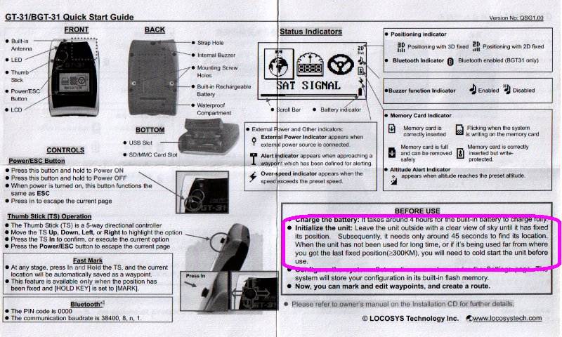
Most of us use GT31 gps they seem the best currently.
yep, the GT31, saves very detailed data to an sd card, so you don't have to worry about loosing data if you can't download it regularly.
For speed accuracy the doppler data is included in the saved file.
I don't know about the best there is, I'm sure you could spend a lot more money and get something more accurate. But for it's cost, it's the best for speed windsurfing, may or may not be relevant to your needs.
Thanks for positivity there T11. I'll check out the GT31 for sure.
If there is any background, sources etc on that 80's windsurf crossing I'd love to know about it.
I did hear a rumour from a random in the shop one day that 2 windsurfers took off from the Cape some years? ago totally unaided and were never heard of again?
Im guessing if it actually happened there would be official records somewhere. Havent found any yet though.
do you want one for the purpose of navigation or just retrospective data (speed tracks etc) ?
G'day Puppet,
Sounds like an adventure![]()
GT31 for data loging
For jumps and all the other twisting loopy spiny stuff the shadowbox is the go as it does the flat data logging as well as altitude and Gyro, it's what they are now using for jump contests
Look forward to reading about it (hopefully not a tale of woe)
I would imagine that because you are planning an offshore adventure, you are wanting to check the gps to tell you where you are. The gt31 won't help with that coz it only logs data for analysis at a later time.
Surely you will need some sort of navigational gps like you would find on a yacht?
Hi Mate
The GT31 is good, and I've got one.. but I would regard it as old technology now. Also, I would regard the product as "fiddly" to use in the field (not a very good field device - buttons can be pressed, data erased/stopped, even when you lock it). Doubly so through the aqua-pack.
I think most modern phones have a GPS chip in them, so anything is possible (ie: "there is an app for that !" etc). A few guys at work like to use thumbdrive type "turn key" devices that fit into their pocket (due to the "accidently pressing something" scenerio). They slide a switch, lock the switch, and it runs.. and then just logs the data. This serves their application well..
.. but the GT31 is still an excellent device. It's got a bunch of other features (not related to Windsurfing) that I use all of the time. Infact, I use it more of other stuff than windsurfing.
Regarding the tracking feature of the GT31 mentioned above. It's very crude. The GT31 also requires a hard power reset after travelling 300km or more.
Whatever the case, make sure the device you purchase logs data in NMEA0183 format (and not solely a proprietary format). This format seems to be the defacto standard for GPS, tracking logging etc, and gives you access to a bunch of free or free to use analysis/visualisation software that is available on the Internet.
Good luck. Let us know what you get :)
J
Is that kinda like an "error located between keyboard and chair" type scenario Kato ? (or fat fingers error ?)![]()
don't get one of those that you use in a car.....it will keep telling you "where possible perform a U turn"![]()