Google Earth coordinates. Copy and paste to Google Earth search.
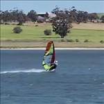
My most used launch site .... 15 min drive from home.
45 25 27.5 N 74 02 24.3 W
Where's yours?
Select to expand quoteelmo said...
who needs a particular location
or to give it away and have it end up over run with tools
Select to expand quoteelmo said..
beach, wind, gear, free time & mates
who needs a particular location
Just as a matter of interest from the other side of the world ( no worries about me invading your spot )
I'm a bit of a slut, I'll sail anywhere with anyone![]()
Mainly sail my locals in Mandurah WA
Select to expand quoteelmo said..
I'm a bit of a slut, I'll sail anywhere with anyone![]()
Mainly sail my locals in Mandurah WA
Same, I go where ever she blows...........
Wind.....
Looks a nice spot. I take it being in that area of Northern America, the lake freezes over in winter ?. Do you have wild temperature ranges like New York or Chicago ?
I have a few spots, depending on the season. All are a 45min - 2hr drive. Google earth is busted on my computer, so here are google map links instead:
Summer (B&J, crash and bash, freestyle, wannabe back end wave sailing etc):
www.google.com.au/maps?ll=-34.848438,138.476455&spn=0.001219,0.00119&t=h&z=20 (the 2nd most windiest place in Adelaide metro. cool crew, easy parking, Noonies..)
maps.google.com.au/?ll=-34.07803,137.543893&spn=0.003479,0.004758&t=h&z=18 (very reliable seabreezes)
maps.google.com.au/?ll=-34.424709,137.922803&spn=0.006929,0.009516&t=h&z=17 (this place blows it's **** off)
Winter (Slalom):
maps.google.com.au/?ll=-34.785554,138.480515&spn=0.00345,0.004758&t=h&z=18 (the flattest water I have ever sailed. Winter northerlies)
maps.google.com.au/?ll=-35.513732,138.797481&spn=0.000855,0.00119&t=h&z=20 (any direction that's not east. Very reliable frontal winds)
maps.google.com.au/?ll=-35.312175,139.189911&spn=0.006855,0.009516&t=h&z=17 (Boggy !. If the winds not up, then stand in front of the fire and gas it)
I have no fear with tools flooding my spots. I am one, and most crew won't sail there anyway LOL :)
Select to expand quotejn1 said..
Looks a nice spot. I take it being in that area of Northern America, the lake freezes over in winter ?. Do you have wild temperature ranges like New York or Chicago ?
It is a nice spot .....from May 15 (best) to Oct 15 (brrrr!). Unfortunately , yes winter is ugly.![]() Once the ice is 3 feet + they open the ice bridge and it's a good short cut to "up north".
Once the ice is 3 feet + they open the ice bridge and it's a good short cut to "up north".
Winter = 2 weeks in Bonaire or Margarita= $$ spent
Select to expand quotejn1 said..
I have no fear with tools flooding my spots. I am one, and most crew won't sail there anyway LOL :)
Not too many around here either. I'll see maybe 3-4 other guys out when I go. A popular spot for people in the Montreal area is across the border in New York state on Lake Champlain. Nice southerlies in the fall, before the water drops below 15C.
44 42 20 N 73 24 17 W
Select to expand quoteBattle said..
44 42 20 N 73 24 17 W
How deep is Lake Des Duex Montagnes and Champlain ?
goo.gl/maps/rL4tZ
Perfect grass.
Always parking.
Tap.
Easy walk to beach.No traffic lights Only one traffic light between there and home.
Works in a few directions.
Select to expand quotejn1 said..Battle said..
44 42 20 N 73 24 17 W
How deep is Lake Des Duex Montagnes and Champlain ?
Deux Montagnes , maybe 40 meters max, Champlain, not sure but must get pretty deep out there.... 120 meters max.